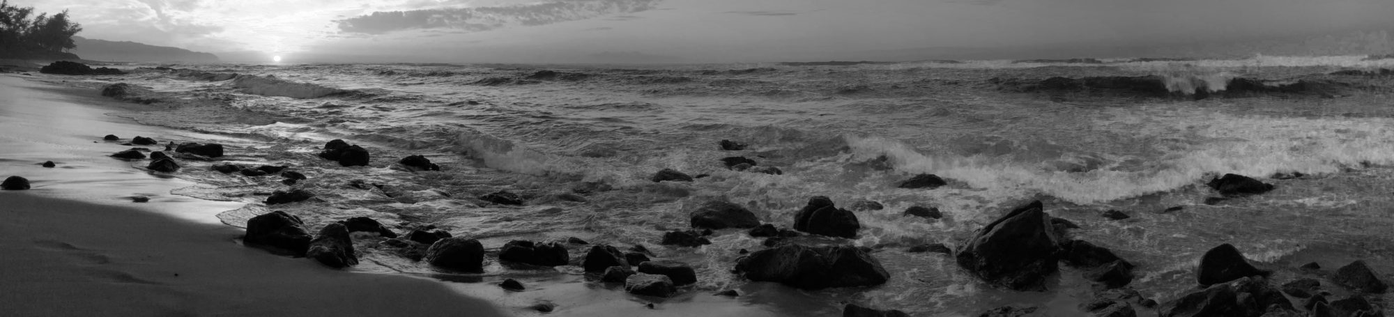
I woke up in Ingonish surprisingly well-rested. I decided to get up and explore a bit more of the rocky beach down the path from the lodge I was staying. You see, I had to see if the beach was suitable for something very near and dear to my heart…
When my dad lay dying a month or so ago, I told him all about this trip and what I was planning on seeing and doing. He faintly smiled and said it sounded like a wonderful trip. I whispered to him that I would take him with me. And so I did, carrying a small aluminum bottle of his ashes with me throughout my birthday adventure.
Carefully clutching the bottle, I made my way down to the rocky shore. A young mother and her two young daughters, whom I had met the night before watching the sunset, were there splashing in the surf while grandpa looked on. Seeing him sent a dagger straight through my heart, thinking how fortunate this woman was to be able to still spend time with her father. I quickly walked away from their happy scene to hide my tears and get some distance where they wouldn’t try to engage me in conversation. I feared that my voice would fail me, leaving me with great gulping sobs as the only sound I could make.
Shortly, I found myself alone on a large, windswept beach littered with thousands and thousands of stones of all shapes and sizes. I stopped at one particular boulder on the beach, contemplating whether it was the right place for me to scatter my dad’s ashes for the first time. It just didn’t feel right so I kept scrambling over the rocks when I saw it, a massive boulder halfway between the sea and the tree line with a large hole right in the middle of the rock’s top. As I walked towards it, I got a sense of “yes, here is the place”. I carefully unscrewed the top and as I poured a small amount of my dad’s ashes into the rock, I whispered to the wind, “You were always my rock Daddy. My love for you will last longer than it will take to wear this stone away.” I was bawling (shit, I’m bawling now typing this) and grateful that I was able to find such a solitary space where I could weep in peace.
I stayed in that spot for a long time, until I was cried out and then let the wind dry my cheeks before I made my way back up the hill to finish packing the car.
The day was crystal clear, sunny and warm. Although I had fully expected it to be misty, rainy, and cold when I was driving the Cabot Trail, I had picture postcard weather. And perfect weather to drive a convertible with the top down. I lathered up on copious amounts of sunscreen and set off. Past Ingonish, the road basically parallels the shoreline, so close you practically dip your hand into the water from your car (not really, but pretty damn close). There are plenty of blogs that have much more lavish descriptions of the exquisite beauty, the ruggedly awe-inspiring views from the road and many scenic overlooks, and the absolute joy it is driving in such a gorgeous setting. So I won’t try to compete. What I will say is that going counterclockwise is not nearly as frightful as some blogs make it out to be (although I would not want to try it in an RV or towing a camper); but then again, I had my beautiful bright-ass orange Mustang GT convertible to negotiate the twisting roads with.
At Lakies Head, there was a turnout to park and drink in the view. When I’m on solo roadtrips like this, I make it a point to pull into every one of those that strike my fancy. And the view did not disappoint. I ended up chatting with the two women who were in the car that followed me into the parking area. One woman is from Ontario while the other flew in from Australia for this girls’ trip. They were both celebrating their 60th birthdays this year and that was their way to mark a momentous occasion. They loved my car (who didn’t) and took some photos of me doing cheese-y kiss-y faces while draped across the hood (I am really a good sport because that certainly was not my idea). They also had two stuffed moose that they took photos of with the spectacular scenery in the background, which I thought was an awesome idea. I regretted not stopping at the airport gift shop to pick a moose up myself.
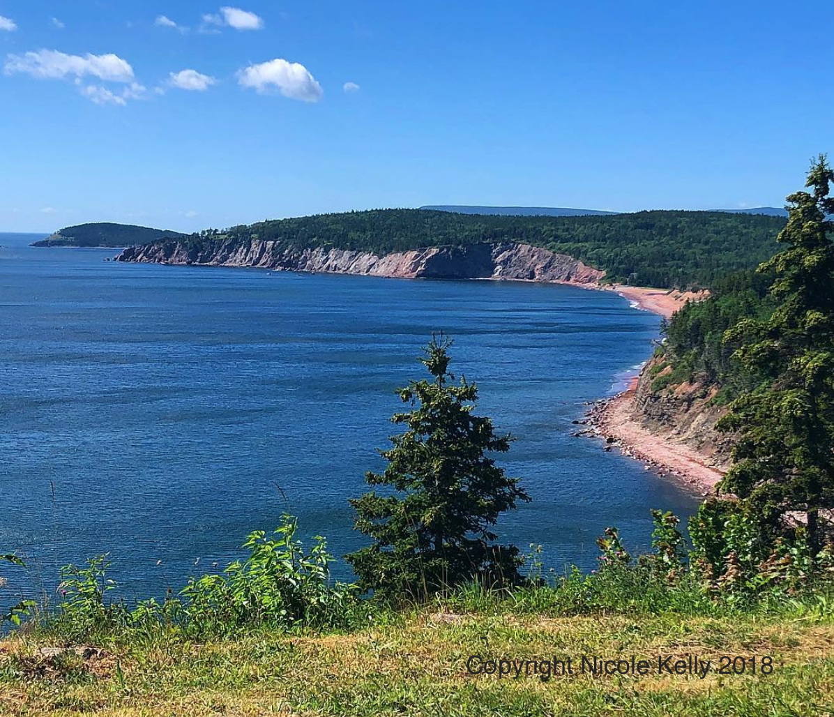
Lakies Head Lookout, Cape Breton Highlands National Park, Nova Scotia
By now, I’m sure you’re all wondering, what name did you bestow upon your fantastic rental car? Because as noted a few posts back, I name pretty much everything. This car gave me some issues though. I originally was trying to call it Trop, as in Tropicana, as in the orange juice. But the car resisted that frivolous name and I kept calling it Thor. Now, my own beloved Mustang GT convertible at home in Austin is already named Thor and it felt wrong to call both of them the same name. But the car was strong and beautiful and built and attracted attention everywhere we went – so very much as if I were to ride around with Chris Hemsworth himself – that Thor just seemed fitting. As a point of clarification, the Mustang I own is called Thor, not after the delectable Mr. Hemsworth (because it was like a decade after I bought the car that the movies came out) but after the old school Norse god; because whenever I start the engine, it feels like I unleash a rumble of thunder.
Anyway, where was I? Ah yes, Lakies Head… I got back into the car and wound my way up passed a number of other rocky coves and hilltops overlooking the incredible scenery. Then, the road turned inland to cut across the top of Cape Breton Island, through the steep and mountainous terrain. As I passed the turn-off for Meat Cove, I was really glad I decided not to try to find that in the dark. I would have either missed it completely and ended up in Cheticamp instead or hit a moose and then careened off the road, down the mountain slope and into the ocean. Neither would have been good outcomes…
At a lookout halfway across the inland portion, I stopped, mostly to let the car behind me pass so I could gawk without worry. But the car turned in behind me. Out came a mother and daughter who immediately wanted to know about my car – how much fun is it to drive, does it get good gas mileage, etc. We ended up chatting for a time. The daughter was in her early 20s and mom close to my age, which kinda threw me for a loop realizing that I was old enough to have a kid in their 20s if I had had the urge to procreate. We joked around about following each other around the Cabot Trail and then I revved the engine on my way back to the road so they could hear how awesome it sounded.
Prior to reaching Cheticamp, there is a trailhead for the Skyline Trail, one of the most hyped (and deservedly so) trails in all of Cape Breton Highlands National Park. I found a parking spot in the crowded lot and took off on the trail. It was simply sublime. The weather was sunny and about 85F / 30C; the trail dips in and out of forested sections, providing shade when you need it most; and I manage to time my arrival to get a mostly solitary hike. I spent some time ruminating about whether my dad would have approved of my decision to scatter his ashes and silently talking to him in my head. At a wildlife viewing platform, I climbed to the top where I was able to enjoy the tranquility for a good 5 minutes before other hikers reached me. And on my way down, I passed a girl who had a t-shirt with my dad’s nickname emblazoned across her chest. And then not more than 5 minutes later, something grabbed my attention and I noticed a woman wearing a shirt that read “I Feel Like a Star”. I get it, when you’re looking for signs, you will see them everywhere. But it set my mind at ease and honestly, if I’m deluding myself, at least I’m not hurting myself.
The trail ends at a rugged cliff that provides a spectacular view of the ocean and the Cabot Trail itself. I am tired of repeating how freaking gorgeous everything is up there but you’re going to have to hear it again… My goodness, what an amazingly beautiful place. On my way back, I saw the mom and daughter from earlier who were on their way to the end of the trail. I promised them it was worth the last 15 minutes left on the hike.
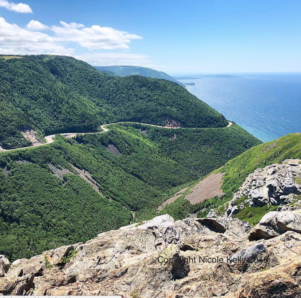
Cabot Trail from Skyline, Cape Breton Highlands, July 2018
I finished the hike and got back on the road. I had a significant amount of driving left to do. Not just completing the Cabot Trail (at that point I was a little more than halfway through the loop) but when plotting out my journey, I decided that I was going to end my day in Charlottetown, Prince Edward Island – about 5.5 hours from where I currently was. Granted, I decided on this plan of action prior to tweaking my back; but fortunately, the seats in the Mustang were really comfortable. And that’s not always a given in a car that is a muscle car rather than a touring vehicle.
But of course I couldn’t just drive straight through when there were still scenic overlooks to check out! I made probably another 6-7 short stops, drinking in the scenery and taking a thousand photos. I somehow ended up behind a vehicle with an Ohio license plate, the only time I ever saw one on the entire trip (another sign from Dad?). The further south you get from the Cape Breton Highlands National Park, the land becomes slightly more tamed and when the Cabot Trail turned inland just south of Cap La Moine, I opted to continue driving the entire 185-mile loop rather than extending down the western shore. I knew I was passing up some more beautiful shoreline scenery; but thought to myself, hey, now I can say I drove the entire Cabot Trail from end-to-end. The interior of the island features mountainous slopes covered in large stands of pine trees. You could actually smell the wood from all of the trees (not the resinous pine sap smell, which I was expecting). There are also a number of rivers and streams that crisscross the landscape. And for a driver, the roads inland are practically deserted. I would go 15-20 minutes without seeing another vehicle.
I finally rejoined the TransCanada Highway just south of Baddeck. I eyed up the sign that pointed east towards the Newfoundland ferries and for a split, impulsive second thought about ditching my plan to head to PEI. But I had a prepaid hotel night waiting for me in Charlottetown (and one of the reasons I prepay hotel nights on tightly scheduled journeys like this is so I don’t unexpectedly end up in Newfoundland sleeping in my car and missing my flight back home because I didn’t think through the consequences of my impulsiveness), so I turned east, driving back to Port Hastings where I crossed the bridge back to mainland Nova Scotia.
I drove the same route I had yesterday along the TransCanada Highway, but this time I was less timid about speeding and passing other vehicles. Thor, my muscle-bound Mustang, actually was a little too fun to drive. The response from when I would hammer down on the accelerator in a passing situation generated some force and every time I looked down at the speedometer after passing someone, I generally hovered around the 160 kph mark. I would say that was slightly above the posted 110 kph speed limit. Gee, I wonder why I was buying gas once a day? Actually, I got really good gas mileage for saying it is a GT and I have a lead foot. The GPS system in the car wanted me to take the PEI ferry even when I purposefully drove past the exit. I couldn’t take the ferry because the ferry does not allow one-way reservations (only standby on the next ferry that has space which in summer is less likely to happen than me getting invited backstage to an Adam Ant concert and not making an idiot of myself). The day after, I had to end up in Moncton, which is way closer to the Confederation Bridge, so I wasn’t about to make a round-trip ferry reservation. The interesting thing is that PEI is like Hotel California. It’s free to go to the Island, either by ferry or bridge. But when you want to leave is when they really make it difficult by making you pay – and pay significantly. The bridge toll is $47 Canadian Dollars, while the ferry is $78 CAD if you book in advance online. So, long story sorta short, I drove the extra 100km to the bridge.
In Nova Scotia on the TransCanada Highway west of Truro on the way to New Brunswick, there is a 45km (28mi) section that has a $4 CAD toll. This toll highway cuts through the Cobequid Pass, an elevation of around 400 meters (1200ft). Geologists say that the Cobequid Mountains are three times older than the Rocky Mountains, and 200 million years ago were probably as tall as the Rockies, but erosion has obviously worn down their height. Anyway, the reason why I’m telling you this is that in a convertible, this section gets chilly and there is a better than usual chance of rain. I ended up pulling over to the side of the road and putting the top up right before a significant downpour. And behind me was the most sturdy rainbow I have ever seen (yet another sign from Dad? C’mon, give me that hope).
The rain didn’t last long and before I knew it, I was pulling off at an exit so I could put the top down again. The Canadians love roundabouts, even when you think you’re in the middle of a highway. I am deeply grateful that I had GPS in my car, even though her voice got slightly aggravated when I would make her recalculate (and oddly, she didn’t actually say “recalculating” but you could hear it implied in her voice). So I managed to take all the correct roundabout exits to finally get me to the Confederation Bridge that links New Brunswick and Prince Edward Island. Confession time… I am actually really nervous on bridges. Not pathologically frightened, but uncomfortable and worrying about whether the engineer got his load calculations correct and whether the contractors used substandard rebar and concrete mixtures when constructing the thing. Don’t look at me like that. I live in the United States where our infrastructure is crumbling daily. The 2017 Infrastructure Report Card from the American Society of Civil Engineers gave the national infrastructure a D+. So I have a legitimate reason to feel that way about bridges.
The Confederation Bridge is 8 miles (12.9km) long, one lane in either direction. It is the longest bridge in the world that crosses ice-covered water. (Now obviously in late July, there is no ice when I drove over the Northumberland Strait but…). The bridge opened on May 31, 1997. The entire time I was driving across it (and it seemed to take a very long time at the posted 50 kph speed limit) I was thinking – 1997 is 21 years ago. Has the ice and freezing temperatures degraded the life expectancy of the concrete? The rebar? Why is the damn thing so high? If a section fails, I’m going to be too far above the water to even survive the fall, let alone be able to swim to land… Yes readers, be glad you weren’t in the car with me going over the bridge…
Finally after what felt like a half hour, I made it to the PEI side of the bridge. I don’t think I quite realized how big the island really is just by looking at the map. From the bridge, I still had about 45-50 minutes before I got to the outskirts of Charlottetown. I drove through a rural countryside that looked suspiciously like rural southern Ohio, very farming-centric rolling hills. The GPS took me a dead-body way through back streets in Charlottetown neighborhoods before finally depositing me in the parking lot of my boutique hotel. I had had quite a day…I had driven 456.2 km (283 miles) and over 7 hours of total driving time, seeing some of the most spectacular scenery on the planet. And I got to do that with the top down 95% of the way!
My driving journey through the Canadian Maritimes will continue in the next installment because this post is getting way too long.
Pingback: Bday Trip 2018 – Getting to Cape Breton | Pink Melanoma
Pingback: Bday Trip 2018 – Island Driving | Pink Melanoma
Pingback: Getting to Cape Breton Island | Pink Melanoma
Pingback: Driving PEI | Pink Melanoma
Pingback: Thanksgiving Abroad 2019 – Northern Tuscany | Pink Melanoma